
What is ...
G P S
The position is acquired by the
principal of triangulation/trilateration
you need at least 3 values
(from satellites) to determine a position.
at least 4 satellites need to be in sight to make sure your position is correct
initiated/developed by USAF
WHO
maintains + operates the system
- consists of 24 to 32 satellites;
~ 12.600 nm above the earth
- 32 satellites as of Dec. 2012
ON THE GROUND
- Master Control Stat.
(Schiever AFB CO Springs)
- 3/4 Ground antennas
- 6 monitor Stations
Besides GPS, the (most common) name or terms for navigation,
there is also “GLONASS”
developed & maintained by Russia.
The constellation of 32 satellites
(see System) supposed to ensure an adequate coverage of satellites to the user at any time while on the ground or in the air.
How is your aircraft's position determined?
As stated above, GPS position determination works on the principle of trilateration
(tri = 3), so at least 3 satellites must be visible or receivable by the GPS receiver in order to determine an aircraft's position.
What does the GPS-Receiver do?
The aircraft's GPS unit receives signals from the satellites.
The satellites transmit a code called a 'coarse acquisition' (C/A),
which contains information about its position, time (derived from an atomic clock), health (reliability) and accuracy of the satellite and the aircraft's receiver will calculate the time it took this signal to travel. Satellite Signals travel at about 186.000 miles/sec
With the information of at least 3 satellites we can determine our position.
As you can see in this picture, the circles meet/cut each other at 2 points.
With this information we still don't know our exact location (we could be located at either point).
With a 3rd Satellite, we can now determine our approximate position, as it cuts through one of the 2 points of the other satellites.
A 4th satellite will assure position accuracy and is practically required, provided a Barometric Altimeter (aka Baro-Aiding) is installed in the aircraft. Besides, the more satellites we have the more exact the receiver can tell where we are.
What else can the receiver do with the Satellite's signal?
As already mentioned, it can provide distance and bearing information to waypoints (WP) as well as ground speed. The WPs that can be determined depend on the database (and its currency) of the receiver.
What else should I know or be aware of as a pilot?
The receiver is usually equipped with 'RAIM'.
What is RAIM?
Receiver – Autonomous – Integrity – Monitoring
→ this function monitors the quality and health of satellite signals.
If it detects any abnormalities, it will let you know with either of the 2 messages:
- not enough satellites are A/V to provide RAIM
→ a satellite indicates a potential error that exceeds safety for a phase of your flight
RAIM must issue an alarm within 30 sec for enroute flying,
-
for Non-Precision approach operations within 10 sec of detecting any issues
Who is responsible for the proper Satellite operation?
The DoD (Department of Defense)
How accurate is GPS flying?
During your flight, there are 3 Modes also known as RNP
(Required Navigation Performance) between which your receiver
should automatically switch...
DEPARTURE – Mode
→ giving you a lateral (horizontal) accuracy (RNP) of 1.0 miles to either side of your track
(Magenta Line) to be flown – will be activated when reaching the Dept. leg.
ENROUTE – Mode
→ giving you a lateral (horizontal) accuracy (RNP) of 2.0 miles to either side of your track
(Magenta Line) to be flown – will be activated when you are on your Enroute Segment
TERMINAL/ARRIVAL – Mode
→ same as Departure Mode – will be activated when you are within 30nm of your destination airport
APPROACH – Mode
→ giving you a lateral (horizontal) accuracy (RNP) of 0.3 miles to either side
of your track (Magenta Line) to be flown – will be activated when within 2nm of your Final Approach Waypoint
What is RNP?
Required Navigation Performance ...
... tells you how precise (exact) your position is, relative to your desired track and can be determined by your GPS receiver. An RNP value of 3.0 means your GPS unit is able to keep you within ~ 3nm of your track. In other words, it must be able to assure you (perform with) this accuracy. This becomes especially important if you fly approaches through valleys or other difficult mountainous terrains.
What is RNAV?
Area Navigation (RNAV), so to say, provides the basis of all GPS Navigation.
It enables a pilot a Point To Point (straight-line) navigation via a GPS unit.
Besides other data, the GPS unit calculates the distance and time between (2) points.
What is WAAS?
Wide Area Augmentation System, falls into the category of SBAS, short for 'Satellite Based Augmentation System'. It is more precise than the regular GPS.
The entire system consists of 2 GEO Satellites, 2 fixed Master Control Stations, located at each of the U.S. coast's as well as a few Wide Area Reference Stations located at different positions on U.S. soil. These stations continuously monitor the Satellites' accuracy and data.
With this accuracy and provided you have a GPS receiver with WAAS capability on board, your position can be determined very precisely, which in turn allows you
to fly precise approaches to many airports, nowadays, even into remote areas.
Here is a Step by Step explanation of the signal's travel:

This illustration is for explanatory purposes only!

1. The WRS monitors the signals for inaccuracies and detects possible errors.
2. Information is then forwarded to the 2 available WAAS Master Stations over the ground.
3. WAAS - Augmentation (where the name comes from) messages are generated, which can remove signal errors.
4. Augmented messages
are sent from the Master Stations to the Geo-Satellites (Up-Link Stations).
5.
The Geo-Satellites send the messages as a GPS-like signal to your aircraft's receiver.
6.
Your WAAS receiver reads that messages and estimates your position.
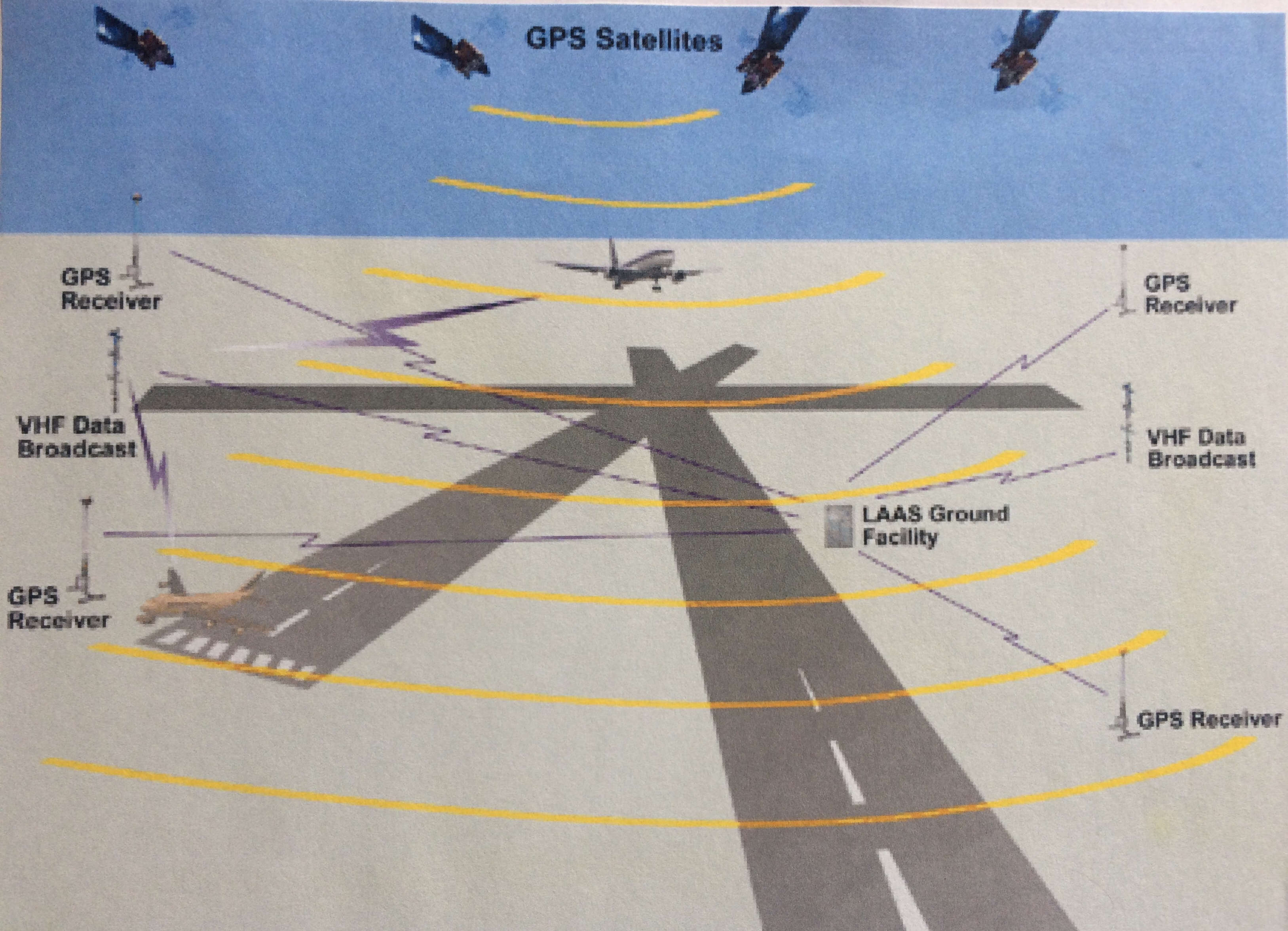
What is LAAS?
Local Area Augmentation System, falls into the category of GBAS, short for Ground Based Augmentation System (as called by ICAO), is part of or can supplement the WAAS. As the name already implies, it's a Local Area System. At airports equipped with LAAS, the pilot can shoot ILS-Category II/III like-approaches, ONLY IF WAAS is also available to the pilot at the same time. LAAS alone enables you to fly approaches to Category I-ILS approaches minimums. The LAAS Ground Equipment compares the data received from the WAAS satellites and it's own and sends a correcting message to the aircraft's receiver. The signals can be received through a VHF Datalink. The system provides an accuracy of about 16M laterally and 4M vertically.
Advantages over other Ground Based Navigation
The advantages over other Precision Approaches at airports are as follows:
With LAAS (GBAS) equipment installed at an airport, it's possible to fly precision approaches to multiple runways instead of just those where ILS (LOC & GS antenna) would be installed. This saves a lot of costs overall. It can only be installed in a radius of about 25nm around airports. Again!, the aircraft must be equipped with LAAS instruments in order to use it!
GPS APPROACHES
What kind of Guidance is available?
RNAV
Simply said, it provides a straight line from one point to another, in other words,
from A to B, whereby A as well as B could be an airport or just another waypoint.
LNAV/VNAV (Lateral/Vertical Nav Guidance) are only subsystems of RNAV and
are part of the automatic flight system.

LPV
Localizer Performance with Vertical Guidance, is a precision approach, that uses WAAS GPS ONLY. Most desired approach, offers the lowest minimums with GPS/WAAS equipment; ILS Cat-1like approaches are possible, 'DH ~ 200-250ft '.
LP
Localizer Performance without Vertical Guidance. LP & LNAV use MDA's.
Used where the surrounding terrain of airports does not permit a vertically guided descent.
LNAV/VNAV
Non-precision approach, Lateral Navigation (guidance) from GPS and/or WAAS + Vertical Navigation (guidance) from barometric altimeter or WAAS.
IF no WAAS, the pilot must have a VNAV altimeter. 'DH is normally around 300'.
LNAV
Non precision approach, uses GPS and/or WAAS for Lateral Navigation.
No vertical guidance provided. Typically has an 'MDA of 400'
Sample IAP showing different Minimums for different approaches!